Form 7480-1 Notice of Landing Area Proposal
Notice of Construction, Alteration and Deactivation of Airports
draft-faa-form-7480-1-notice-construction-2025-11-18
Notice of Landing Area Proposal
OMB: 2120-0036
DRAFT
![]()
U.S.
Department
Of Transportation
Federal
Aviation
Administration
FAA 7480-1, Notice for Construction, Alteration and Deactivation of Airports
Privacy Act Statement (5 U.S.C. § 552a, as amended)
AUTHORITY: The FAA is responsible for issuing a determination based on extensive analysis completed in accordance with 49 United States Code (USC) Section 44502. Title 14 of the Code of Federal Regulations (14 CFR), part 157 authorizes FAA to collect this information. PURPOSE(S): FAA will use this information to conduct airport airspace analyses and determine impact on airport operations or the safety of air navigation. ROUTINE USE(S): In accordance with DOT's system of records notice, DOT/ALL 16 Mailing Management System & DOT/FAA 826 Petitions for Exemption, Other than Medical Exemption-Public Dockets, the information provided may be disclosed to officials within the Federal government and the public in general.
Paperwork Reduction Act Burden Statement
A federal agency may not conduct or sponsor, and a person is not required to respond to, nor shall a person be subject to a penalty for failure to comply with a collection of information subject to the requirements of the Paperwork Reduction Act unless that collection of information displays a currently valid OMB Control Number. The OMB Control Number for this information collection is 2120-0036. Public reporting for this collection of information is estimated to be approximately 60 minutes per response, including the time for reviewing instructions, searching existing data sources, gathering and maintaining the data needed, completing and reviewing the collection of information.
All responses to this collection of information are required if the proponent wishes to have the airport on file with the FAA, as required by Title 14 Code of Federal Regulations Part 157 and entered into the National Airspace System. No assurances of confidentiality are given. Send comments regarding this burden estimate or any other aspect of this collection of information, including suggestions for reducing this burden to: Information Collection Clearance Officer, Federal Aviation Administration, 10101 Hillwood Parkway, Fort Worth, TX 76177-1524.
When to File a Notice for Construction, Alteration and Deactivation of Airports
The FAA encourages you to file electronically at: https://adip.faa.gov/agis/public/#/public
Title 14 Code of Federal Regulations Part 157 requires all persons to notify the FAA at least 90 days before construction, alteration, activation, deactivation, or change to the status or use of a civil or joint-use (civil/military) airport. (As used herein, the term “airport” means any Landing or Takeoff Area, e.g., Airport, Heliport, Vertiport, Gliderport, Seaplane Base, Ultralight Flightpark, or Balloonport.)
Notice is not required for:
An airport subject to the conditions of a federal agreement that requires an approved current airport layout plan to be on file with the Federal Aviation Administration.
Establishment of a temporary airport at which operations will be conducted under visual flight rule (VFR) and will be used for less than 30 days with no more than 10 operations per day.
Intermittent use of a site that is not an established airport, which is used for less than one year and at which flight operations will be conducted only under VFR. (Intermittent use means the use of the site for no more than 3 days in any one week and for no more than 10 operations per day.)
Each person who intends to take any action below must submit the required notice:
Construct or otherwise establish a new airport or activate an airport.
Construct, alter, realign, or activate any runway, or other aircraft landing or takeoff area of an airport.
Construct, alter, realign, or activate a taxiway associated with a landing or takeoff area on a public-use airport.
Deactivate, discontinue using, or abandon an airport or any landing or takeoff area of an airport for a period of one year or more.
Deactivate, abandon, or discontinue using a taxiway associated with a landing or takeoff area on a public-use airport.
Change the status of an airport from private use (use by the owner or use by the owner and other person authorized by the owner) to an airport open to the public or from public-use to another status.
Change status from IFR (Instrument Flight Rules) to VFR or from VFR to IFR.
Establish or change any traffic pattern or traffic pattern altitude or direction.
Section 901 of the Federal Aviation Act of 1958, as amended, provides that any person who violates a rule, regulation, or order issued under Title III of this Act will be subject to a civil penalty not to exceed $1,000 for each violation.
General Instructions – Form Completion
Please contact the local ADO or Regional office for filing instructions.
Section A – Airport Owner
Complete this section.
Item A.1: Provide the name of the Airport Owner.
Item A.2: Enter an “Attention of” name if that applies.
Item A.3: Enter the airport owner’s street address.
Items A.4:
Enter the airport owner’s city, state, and zip code.
Check the related check box if this is the airport’s physical address.
Items A.4, 5, and 6: Enter the airport owner’s phone number, any phone extension number, FAX number, and email address.
Section B – Property Owner
Check the related box if the Property Owner is the same as the Airport Owner. If so, see the next check box if applicable and then go to Section C. If the Property Owner is not the same, complete this section.
Check the related box if the airport is a First Responder facility.
Item B.1: Enter the property owner’s name.
Item B.2: Enter the property owner’s street address.
Items B.3:
Enter the property owner’s city, state, and zip code.
Check the related box if this is the airport’s physical address.
Items B.4, 5, and 6: Enter the property owner’s phone number, any phone extension number, FAX number, and email address.
Section C – Airport Manager
Check the related box if the Airport Manager is the same as the Airport Owner and then identify if the Airport Manager is the same as the Property Owner.
If the Airport Manager is the same as either the Airport or Property Owner, go to Section D. If the Airport Manager is not the same as either the Airport or Property Owner, complete this section.
Item C.1: Enter the airport manager’s name.
Item C.2: Enter the airport manager’s street address.
Items C.3:
Enter the property owner’s city, state, and zip code.
Check the related box if this is the airport’s physical address.
Items C.4, 5, and 6: Enter the airport manager’s phone number, any phone extension number, FAX number, and email address.
Section D – Facility Address
Check the related box if the Facility Contact Information is the same as the Airport Owner. If so, go to Section E. If the Facility Contact Information is not the same, complete this section.
Item D.1: Enter the name of the responsible person.
Item D.2: Enter facility’s street address.
Item D.3: Enter the facility’s city, state, and zip code.
Items D.4, 5, and 6: Enter the facility’s phone number, any phone extension number, FAX number, and email address.
Section E – Purpose of Notification
Provide the reason for notification by completing all applicable items in this section. Report only one action per form.
Item E.1: Choose one type of facility.
Item E.2: Choose one. For a public-use taxiway, include information in box C.6. Description and depict taxiway layout on airport drawing or sketch.
Item E.3: Choose any. If the change is from VFR to IFR, include anticipated IFR procedure.
Item E.4: Indicate if the change is to Direction and/or Altitude.
If Direction, enter the new direction.
If Altitude, choose the type(s) changed and indicate if the change is to standard or nonstandard for each type changed. If nonstandard, enter the nonstandard altitude. If Other, describe the change in box E6.
Item E.5: If this is a deactivation, choose the type: Airport, Runway, Taxiway, or Helipad/Vertipad. Identify the specific Runway, Taxiway, or Helipad/Vertipad if applicable. Include abandonment date in box 6.
Item E.6: Provide appropriate information.
Section F – Landing Area Information
Provide all applicable information.
Item F.1: Enter name of landing area.
Item F.2: Enter the FAA Location Identifier (LOCID) for an existing Airport.
Item F.3: Enter the city and state that the facility serves and with which it is normally associated.
Item F.4: Enter the physical state in which the facility is located.
Item F.5: Enter the County in which it is physically located.
Item F.6: Enter the direction, to the nearest eighth compass point (i.e., E, SE, etc.), from the Associated City (F.3) to the landing area.
Item F.7: Enter straight-line distance, to the nearest nautical mile, from the Associated City (F.3) to the landing area.
Items F.8, 9, 10, 11: Enter the Latitude and Longitude of the Airport Reference Point and the Airport Elevation. The airport reference point can be calculated by using the NGS tool located at NOAA (http://www.ngs.noaa.gov/AERO/arpcomp/arpframe.html). The Airport elevation is the highest point of an airport's usable runways measured in feet above mean sea level.
Item F.12: Choose one Current Use option.
Item F.13: Choose one Ownership option.
Item F.14: Select primary Landing Area Type. If Heliport, (select design type) General Aviation, Transport, Hospital/Ambulance, or VTOL. Choose these options only if Heliport is the primary airport type.
Section G – Landing Area Data
Provide all applicable information.
Item G.1:
Address each runway end independently, if applicable.
For an Airport/Runway: Provide a detailed drawing and/or imagery of the proposed landing area depicting latitude, longitude, length, and width.
The document(s) must show the runway orientation in relation to known roads, terrain etc. such that the FAA can locate the runway(s) accurately and efficiently.
Notate any obstructions (buildings, high-line wires, roads, railroads, towers, etc.) within the vicinity of the runway.
You must include runway end coordinates and the runway elevations on the runway centerline.
Provide runway end coordinates and elevations; and runway threshold coordinates and elevations for runway threshold displacements, if applicable (see the below two example images).
Typical Runway
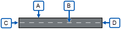
Key to Typical Runway image:
A: Runway edge (typical)
B: Runway centerline (typical)
C: Runway end 09:
Latitude: 20° 26' 50.12"
Longitude: 80° 18’ 30.15”
Elevation: 90' MSL (Mean Sea Level)
D: Runway end 27:
Latitude: 20° 26' 10.12"
Longitude: 80° 18’ 8.5”
Elevation: 91' MSL
Runway with Threshold Displacement
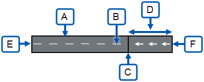
Key to Runway with Threshold Displacement image:
A: Runway edge (typical)
B: Runway centerline (typical)
C: Runway 27 Displacement:
Latitude: 20° 26' 5.08"
Longitude: 80° 18’ 20.03”
Elevation: 91' MSL (Mean Sea Level)
D: 800’ Threshold Displacement
E: Runway end 09:
Latitude: 20° 26' 50.12"
Longitude: 80° 18’ 30.15”
Elevation: 90' MSL
F: Runway end 27:
Latitude: 20° 26' 10.12"
Longitude: 80° 18’ 8.5”
Elevation: 91' MSL
Item G.2:
If a helipad is elevated, provide the elevated height above ground level (AGL) and do not add the AGL height to Above Mean Sea Level (AMSL).
For Heliports, include the TLOF (Touchdown and Liftoff Area), Controlling Dimension, Safety Area, and FATO (Final Approach and Take Off) dimensions.
For a Heliport/Vertiport/Balloonports: Provide a detailed drawing, imagery or map identifying the exact location of the heliport/vertiport in red.
The document(s) must show the helipad(s) in relation to known roads, terrain etc. such that the FAA can locate the heliport accurately and efficiently.
Provide site plan depicting the landing pad in relation to buildings and other obstacles (light poles, fences, trees, bollards, parking lots) near the landing area.
Provide dimensions of the landing pad and the height of the buildings/obstacles and their distance from the helipad.
Provide a heliport layout plan (in accordance with FAA Advisory Circular 150/5390-2, Heliport Design) or Engineering Brief No. 105 (Vertiport Design) identifying the proposed TLOF, FATO, safety area, markings, lights, beacon location, windsock(s), the approach/departure paths (if room allows, the heliport layout plan may be shown on the site plan).
Heliport/Helipad Controlling Dimension (D):
The greater of helicopter overall length (OL) and overall width (OW).
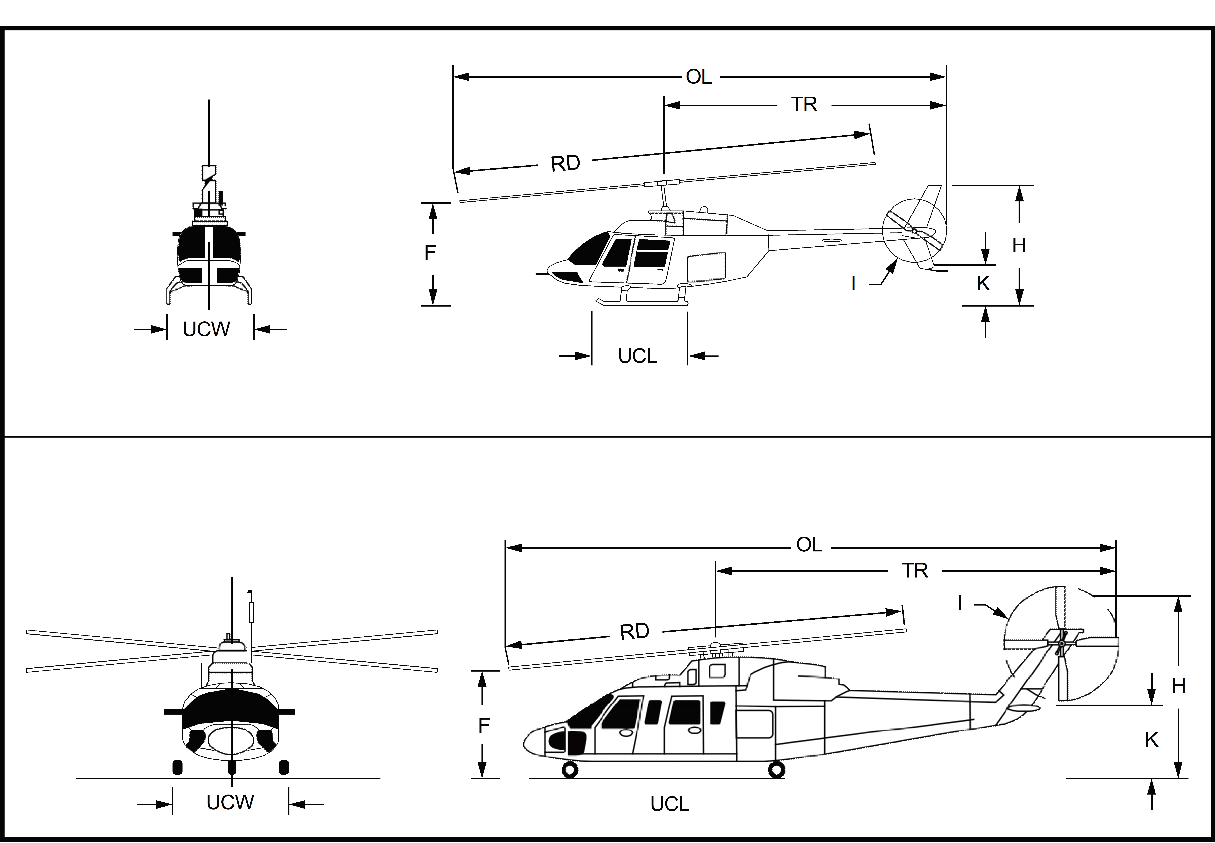
Source: Figure C-1 from Advisory Circular 150/5390-2, Heliport Design.
Heliport Design codes (Figure C-1 above)
Code |
Definition |
A |
Manufacturer name and helicopter model |
B |
Maximum takeoff weight in pounds |
D |
Controlling dimension |
E |
Number of blades |
F |
Rotor plane clearance in feet |
H |
Overall height in feet (usually at tail rotor) |
I |
Tail rotor diameter (in feet) |
J |
Number of tail rotor blades |
K |
Tail rotor ground clearance in feet |
L |
Type of undercarriage |
M |
Number and type of engines |
N |
Number of crew and passengers |
OL |
Overall helicopter length in feet (rotors at their maximum extension) |
OW |
Overall aircraft width in feet |
RD |
Rotor diameter in feet |
TR |
Distance from rotor hub to tip of tail rotor in feet |
UCL |
Undercarriage length in feet |
UCW |
Undercarriage width in feet (distance between outside edges of tires or the skids) |
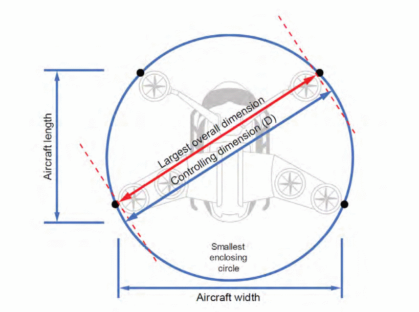
Vertiport/Vertipad Controlling Dimension (D):
Section H – Operational Data
Provide all applicable information.
Section I – Certification
All information is required and must be complete.
Notification to the FAA does not waive requirements of any other government agency.
Regional Office Addresses
Submit your completed form by mail to the appropriate regional office.
Alaskan Region
AK
U.S. Department of Transportation
Federal Aviation Administration
Alaskan Region Airports Division, AAL-600
222 W. 7th Ave, M/S #14
Anchorage, AK 99513
Tel: (907) 271-5438 Fax: (907) 271-2851
Central Region
IA, KS, MO, NE
U.S. Department of Transportation
Federal Aviation Administration
Central Region Airports Division, ACE-600
901 Locust St., Room 364
Kansas City, MO 64106-2325
Tel: (816) 329-2600 Fax: (816) 329-2610/2611
Eastern Region
DC, DE, MD, NJ, NY, PA, VA, WV
U.S. Department of Transportation
Federal Aviation Administration
Eastern Region Airports Division, AEA-600
1 Aviation Plaza
Jamaica, NY 11434
Tel: (718) 553-3330 Fax: (718) 995-5694
Great Lakes Region
IL, IN, MI, MN, ND, OH, SD, WI
U.S. Department of Transportation
Federal Aviation Administration
Great Lakes Region Airports Division, AGL-600
2300 East Devon Avenue
Des Plaines, IL 60018-4696
Tel: (847) 294-7272
New England Region
CT, MA, ME, NH, RI, VT
U.S. Department of Transportation
Federal Aviation Administration
New England Region Airports Division, ANE-600
1200 District Avenue
Burlington, MA 01803-5078
Tel: (781) 238-7600 Fax: (781) 238-7608
Northwest Mountain Region
CO, ID, MT, OR, UT, WA, WY
U.S. Department of Transportation
Federal Aviation Administration
Northwest Mountain Region Airports Division, ANM-600
2200 S 216th St
Des Moines, WA 98198
Tel: (206) 231-4100 Fax: (206) 231-EXT
Southern Region
AL, FL, GA, KY, MS, NC, TN, SC, PR, VI
U.S. Department of Transportation
Federal Aviation Administration
Southern Region Airports Division, ASO-600
1701 Columbia Ave., Suite 540
Atlanta, GA 30337
Tel: (404) 305-6700 Fax: (404) 305-6730
Southwest Region
AR, LA, NM, OK, TX
U.S. Department of Transportation
Federal Aviation Administration
Southwest Region Airports Division, ASW-600
10101 Hillwood Parkway
Fort Worth, TX 76177
Tel: (817) 222-5600 Fax: (817) 222-5987
Western-Pacific Region
AZ, CA, HI, NV
U.S. Department of Transportation
Federal Aviation Administration
Western-Pacific Region Airports Division, AWP‑600
777 S Aviation Blvd, Ste 150
El Segundo, CA 90245
Tel: (424) 405-7300
|
U.S. Department of Transportation Federal Aviation Administration |
OMB CONTROL NUMBER: 2120-0036 EXPIRATION DATE: 12/31/2025 |
Notice for Construction, Alteration and Deactivation of Airports
A. Airport Owner
1. Name of Airport Owner *:
2. Attention of:
3. Street Address *:
4. City, State, Zip code *:
Check if this is the Airport’s Physical Address
5. Phone *: Ext:
6. Fax:
7. Email *:
B. Property Owner
Check if this is also the Airport Owner. (Skip to section C.)
Check if this airport is a First Responder facility.
1. Name of Property Owner *:
2. Street Address *:
3. City, State, Zip code *:
Check if this is the Airport’s Physical Address
4. Phone *: Ext:
5. Fax:
6. Email *:
C. Airport Manager
Check if this is also the Airport Owner. (Skip to section D.)
Check if this is also the Property Owner. (Skip to section D.)
1. Airport Manager Name *:
2. Street Address *:
3. City, State, Zip code *:
Check if this is the Airport’s Physical Address
4. Phone *: Ext:
5. Fax:
6. Email *:
D. Facility Address
Check if this is also the Airport Owner. (Skip to section E.)
1. Name of Responsible *:
2. Street Address *:
3. City, State, Zip code *:
4. Phone *: Ext:
5. Fax:
6. Email *:
E. Purpose of Notification
Answer all that apply.
1. Construct or Establish a (choose one):
Airport Heliport Seaplane Base Vertiport Ultralight Flight Park
Other:
2. Construct, Alter or Realign a (choose one):
Runway Helipad(s) Taxiway (Public Use Airports only) Vertipad
Other:
3. Change Status From/To (choose any):
VFR to IFR IFR to VFR Private Use to Public Use Public Use to Other
If change is from VFR to IFR, include anticipated IFR procedure:
4. Change Traffic Pattern:
Direction:
Altitude: (Choose an aircraft type. If nonstandard, enter altitude.)
Turbo: Standard Prop: Standard Nonstandard. Altitude:
Helo: Standard Nonstandard. Altitude: Other (Describe in Item E6)
5.
Deactivate (Choose one. Identify Runway, Taxiway, or
Helipad/Vertipad):
Airport
Runway: Taxiway:
Helipad/Vertipad:
6. Description:
F. Landing Area Information
1. Name of Landing Area *:
2. LOCID (for existing):
3. Associated City and State *:
4. State *:
5. County (physical location) *:
6. Direction from City *:
7. Distance from City (nm) *:
Airport Reference Point (ARP)
8. Latitude: ° ' " Direction
9. Longitude: ° ' " Direction
10. Facility Elevation (ft):
11. Ultimate Elevation (ft) *:
Landing Area Use & Type
12. Current Use *: Private Public Private Use of Public Land/Water
13. Ownership *: Private Public Military (Branch) Coast Guard
14. Facility Type *: Airport Heliport Seaplane Base Ultralight Flightpark
Vertiport Gliderport Balloonport
(If Heliport, choose): General Aviation Transport Hospital/Ambulance
VTOL
G. Landing Area Data
List any Proposed, New or Unregistered Runways, Helipads, etc.
1.
Airport, Seaplane Base or Ultra Flight Park, and
Gliders
(If additional runway ends are impacted, also attach
a file with the following information)
Data Type |
Runway End |
Runway End |
RWY/Sealane Identifier |
/ |
/ |
Lat. & Long. |
Show on attachment(s) |
Show on attachment(s) |
Surface Type |
|
|
Length (feet) |
|
|
Width (feet) |
|
|
Center Point Lat. |
|
|
Center Point Long. |
|
|
Center Point Elev. (AMSL) |
|
|
Displacement Threshold Lat. |
|
|
Displacement Threshold Long. |
|
|
Displacement Threshold Elev. (AMSL) |
|
|
Marking Type |
|
|
Approach Lighting (if any) |
|
|
Right Traffic (Y/N) |
/ |
/ |
Elevation (AMSL) |
Show on attachment(s) |
Show on attachment(s) |
VFR or IFR |
/ |
/ |
Part 77 Code |
|
|
2.
Heliport, Vertipad or Balloonpad Information
(If
additional runway ends are impacted, also attach a file with the
following information)
Data Type |
H1 |
H2 |
Identifier |
|
|
Lat. & Long. |
Show on attachment(s) |
Show on attachment(s) |
Surface Type |
|
|
Controlling Dimension |
|
|
TLOF Dimensions |
|
|
TLOF Elevation (AMSL) |
|
|
FATO Dimensions |
|
|
Safety Area Dimension |
|
|
Lighting (if any) |
|
|
Primary Ingress/Egress (Degrees) |
|
|
Secondary Ingress/Egress (Degrees) |
|
|
Elevation (AMSL) |
Show on attachment(s) |
Show on attachment(s) |
TLOF Elevated Height (AGL) |
|
|
Lighting |
|
|
Heliport/Vertiport Crossing Height (HCH/VCH) |
|
|
Heliport Crossing Height (HCH) |
|
|
Helicopter Weight (lbs) |
|
|
Controlling Dimension (FT) |
|
|
H. Operational Data
Indicate if the number provided is Estimated.
Aircraft type |
|
Based Aircraft (number) |
Average Monthly Landings (number) |
|||||
Present |
Estimated (Yes/No) |
Estimated in 5 Years |
Present |
Estimated (Yes/No) |
Estimated in 5 Years |
|||
Single Engine |
|
|
|
|
|
|
||
Multi Engine |
|
|
|
|
|
|
||
Jet |
|
|
|
|
|
|
||
Helicopter |
|
|
|
|
|
|
||
vTOL |
|
|
|
|
|
|
||
Glider |
|
|
|
|
|
|
||
Military |
|
|
|
|
|
|
||
Ultralight |
|
|
|
|
|
|
||
1.
What is the most demanding aircraft that operates or will operate at
the airport?
(Provide approach speed, rotor diameter,
controlling dimension, MTOW, etc.):
2.
Are IFR procedures for the airport anticipated?
Yes No.
If Yes, within years.
I. Certification
I hereby certify that all of the above statements made by me are true and complete to the best of my knowledge.
1. Name of person filing this notice (type or print):
2. Title of person filing this notice (type or print):
3. Signature (digital or in ink):
4. Date signed: 5. Phone:
6. Email address:
| File Type | application/vnd.openxmlformats-officedocument.wordprocessingml.document |
| File Title | DRAFT FAA Form 7480-1, Notice for Construction, Alteration and Deactivation of Airports, November 2025 |
| Subject | Use this form to notify the F A A at least 90 days before construction, alteration, activation, deactivation, or change to the s |
| Author | F A A Airport Engineering Division (AAS-100) 202-267-7669 |
| File Modified | 0000-00-00 |
| File Created | 2025-12-09 |
© 2026 OMB.report | Privacy Policy