Form 3-2526 Midwest Geographic Area: Bumble Bee Reporting Form
Federal Fish and Wildlife Permit Applications and Reports - Native Endangered and Threatened Species; 50 CFR 10, 13, and 17
FWS Form 3-2526 US Fish and Wildlife Bumble Bee Reporting Form 10092020.xlsx
Annual Report (Form 3–2526 Midwest Geographic Area: Bumble Bee Reporting Form) - Government
OMB: 1018-0094
⚠️ Notice: This form may be outdated. More recent filings and information on OMB 1018-0094 can be found here:
Document [xlsx]
Download: xlsx | pdf
Primary Information
Effort and Area
Individual Bee Data
Habitat Data
Detailed Habitat Assessment
Photographs
Printable Survey Forms
Definitions
Required Notices
Overview
InstructionsPrimary Information
Effort and Area
Individual Bee Data
Habitat Data
Detailed Habitat Assessment
Photographs
Printable Survey Forms
Definitions
Required Notices
Sheet 1: Instructions
| FWS Form 3-2526 (Rev. 10/2020) OMB Control No. 1018-0094 Expires ##/##/20## |
||||||||
| About the Rusty Patched Bumble Bee Electronic Reporting Spreadsheet | 1 Prior to data submittal, permittees should ensure they are using the most current version of the permit reporting spreadsheet, which is available on the Services' R3 rusty patched bumble bee survey website: https://www.fws.gov/midwest/endangered/insects/rpbb/surveys.html | |||||||
| In an effort to reduce redundancy, increase efficiency, and minimize data entry errors, the U.S. Fish and Wildlife Service (Service) in Region 3 (Illinois, Indiana, Iowa, Michigan, Minnesota, Missouri, Ohio, and Wisconsin) has created a single standardized spreadsheet1 for electronic submittal of bee survey data by federal permittees to the Service. Federal Recovery Permits for rusty patched bumble bee include terms and conditions requesting submission of data in this standardized reporting spreadsheet. Permittees are encouraged to submit their survey data via the standardized permit reporting spreadsheet not only to facilitate determination of reporting compliance, but also to facilitate improved assemblage of data to determine impacts on the species. If permittees intend to collect additional data that does not fit within the format of this spreadsheet, they should coordinate with the Service Field Office for the study area regarding how to report the additional data. If multiple Federal permittees are contracted and/or subcontracted to conduct bee surveys as part of a single large project, each permittee is required to separately report the bee data collected under their permit so that the permittee responsible for data collected within a specific survey site can be clearly identified. DO NOT move columns or adjust the format of this spreadsheet. |
||||||||
| A Note to Users | ||||||||
| Use of this electronic reporting spreadsheet is optional at this time. However, the Service is taking steps to refine and formalize the spreadsheet with the intention of requiring Federal recovery permit holders to submit annual reports using this spreadsheet. Data requested in “Survey Location", Survey Area”, “Habitat Data”, and “Individual Bee Data” (highlighted in blue) worksheets are required for Federal Recovery Permit holders to fulfil annual reporting requirements. The “Detailed Habitat Assessment” worksheet is recommended for researchers surveying at a long-term monitoring site, or for those interested in more habitat detail. This detailed habitat datasheet was largely based on the Rusty Patched Bumble Bee Habitat Assessment Form and Guide by The Xerces Society. For more detailed information about data collection and survey methods, see the Survey Protocol and Guidance for the rusty patched bumble bee (Bombus affinis) online at: https://www.fws.gov/midwest/endangered/insects/rpbb/surveys.html |
||||||||
| General Instructions | ||||||||
| The spreadsheet is divided into several worksheets (i.e., Required – Primary Information, Effort and Area, Individual Bee Data, and Habitat Data. Optional - Detailed Habitat Assessment" and "Photographs"). It is important to start by filling out the “Primary Information” worksheet first for whichever surveys have been completed because the information from these worksheets populates drop-down boxes in other worksheets. For the required worksheets, the cells colored blue are required fields, green cells are required if applicable, and gray cells are optional. Cell colors on the detailed habitat assessment worksheet mirror the colors on Rusty Patched Bumble Bee Habitat Assessment Form and Guide. Note: We have included additional information to help you understand the information we are seeking. See the “definitions” tab for column heading definitions. You may also click on the red triangle (the upper right corner of several column headings) to open up comment bubbles with instructions/clarifications on specific columns. Important: DO NOT move columns or adjust the format of this spreadsheet. |
||||||||
| Worksheet Instructions | ||||||||
| Primary Information: The “Unique Survey ID” is an automatically generated unique identifier composed of the permit number, project name, date, and site name. The “Unique Survey ID” will be used throughout the entire database to track the correct survey information. The survey date captures when the survey was conducted. The same location surveyed on multiple dates should be entered as separate rows, since method and species identified may be different on each survey date. | ||||||||
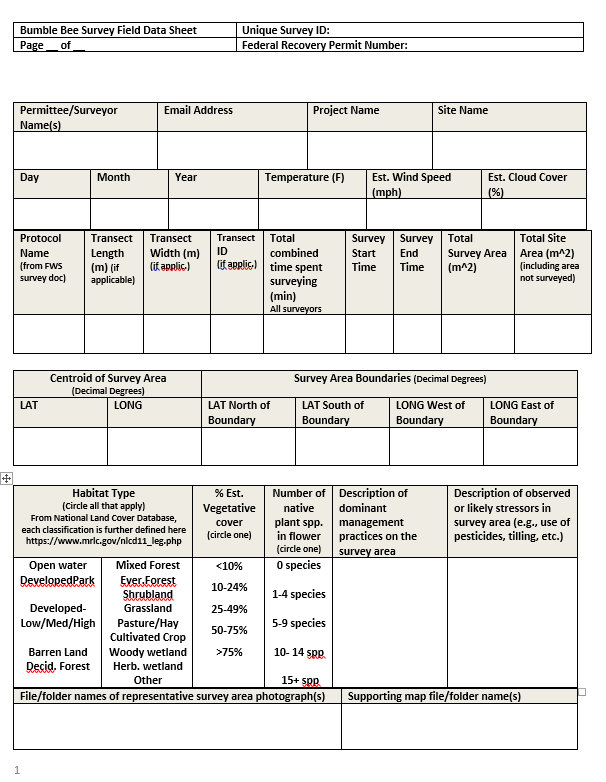
| Effort and Area: The data in this worksheet is for the collection of information survey area boundaries and survey effort. The dropdown menu provides the names of several FWS protocols; a detailed description of those protocols is available online at on the RPBB surveyors website (https://www.fws.gov/midwest/Endangered/insects/rpbb/surveys.html). | ||||||||
| Individual Bee Data: The data in this worksheet is for the collection of information on both federally listed and non-federally listed Bombus at the species level to understand the composition of the Bombus community in the survey area. The majority of fields in the “Individual Bee Data” tab are straight forward in terms of the information being requested. You may group individuals of one species in a row (for example, you can enter 25 female B. impatiens and 5 B. impatiens males in the same row), however, you could alternatively enter individuals in separate rows (for instance, if you wanted to note separate floral use for individual bee(s)). We are requiring unique capture points for federally listed species to be entered separately. If you observe more than one federally listed species at the same point location (roughly, within 25ft of each other), you may enter them together in one row. If you conducted activities, such as DNA collection, pollen collection, tagging, pathogen sampling or used B. affinis for training detection animals, please indicate those activities in the appropriate fields and separate by rows to correctly capture the numbers for each activity without duplicating counts. If using distance sampling, indicate the distance from the transect. | ||||||||
| Habitat Data: The data in this worksheet is for the collection of basic habitat information and survey conditions (e.g., temperature, estimated wind speed). Information on Apis species (Europen honey bee species) observed is also requested on this worksheet (i.e., Are Apis species present and estimated Bombus to Apis ratio). | ||||||||
| Detailed Habitat Data: This worksheet is optional, but is highly recommended for long-term monitoring sites (e.g., recovery monitoring) or sites where you would like to further quantify habitat and stressors. For example, you this form could be used to help collect baseline habitat data before conducting a habitat restoration project and then to evaluate the project post-restoration. The information on this worksheet is largely based on the “Rusty Patched Bumble Bee Habitat Assessment Form and Guidance” developed by the Xerces Society and available on the RPBB surveyors website (https://www.fws.gov/midwest/Endangered/insects/rpbb/surveys.html). You may choose to use the assessment form in the field and transpose your data into this worksheet. | ||||||||
| Photographs: You may embed reduced sized photographs on the "Photographs" tab. Label each with the unique survey ID. See permit conditions for photograph requirements. |
||||||||
| Naming instructions for saving files: If all of the surveys for a permit number are on one spreadsheet (this can be multiple states), save the file as that permit number (e.g., TE000000). If you do not have a permit, use another unique identifier. If all of the surveys have the same permit number but are on several spreadsheets, use a unique identifier for each. For example, if your spreadsheets are broken up by states, use the permit number and then list out the state names (e.g., TE000000_OHIO_INDIANA, TE000000_IOWA). If there are multiple permit numbers from the same organization/individual’s name, use the organization/individual’s name and the state or states (e.g., TE000000_Leibii_Inc_OHIO). To avoid confusion, this should include every survey that organization/individual conducted in that state. Please coordinate within your organization to ensure that multiple individuals aren’t submitting the same data. |
||||||||
| More information is available on the RPBB website (https://www.fws.gov/midwest/Endangered/insects/rpbb/). For questions about using USFWS spreadsheets, contact your local Service Field Office. | ||||||||
Sheet 2: Primary Information
Sheet 3: Effort and Area
Sheet 4: Individual Bee Data
Sheet 5: Habitat Data
Sheet 6: Detailed Habitat Assessment
Sheet 7: Photographs
| Embed reduced sized photographs of B. affinis here. Label with PERMITNUMBER_SITECODE_SPECIMEN#_PHOTO#_DATE (e.g., TE5555-7_STPAUL28_Specimen12_photo2_12July2017). See permit conditions for photgraph requirements. |
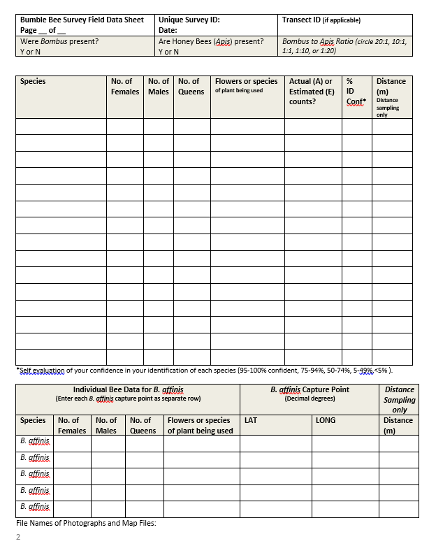
Sheet 8: Printable Survey Forms
|
|
||||||||||||||
Sheet 9: Definitions
| Rusty Patched Bumble Bee Spreadsheet Definitions | |||
| TAB | FIELD | DEFINITION | |
| (highlighted according to whether the data is required or requested) | (Or dropdown list) | (Definitions for dropdowns) | |
| Primary Information | |||
| Federal Recovery Permit Number | Federal permit number. If you do not have a Federal permit, insert a 6 digit alpha numeric code unique to you. | ||
| Unique Survey ID | Automatically generated unique identifier of a specific survey, this is autogenerated composed of the permit number, project name, site name, and date | ||
| Permittee Name | Name one or more of federal permit holder(s) conducting the work | ||
| Email Address for survey contact | Provide one email address for primary contact person | ||
| Project Name | If applicable, the identifier of the project or study for which the survey is conducted | ||
| Site Name | Unique identifier for a specific survey site | ||
| State | Primary state where survey occurred | Drop down list of all Eastern states within the historical range | |
| County | Primary county where survey occurred | ||
| Day | Day in which a survey is conducted at a site; surveying on multiple dates should be entered separately because the method and species observed may be different | ||
| Month | Month in which survey is conducted at a site; surveying on multiple dates should be entered separately because the method and species observed may be different | ||
| Year | Year in which survey is conducted at a site; surveying on multiple dates should be entered separately because the method and species observed may be different | ||
| Effort and Area | |||
| Unique Survey ID | Automatically generated unique identifier of a specific survey, this is autogenerated composed of the permit number, project name, site name, and date | ||
| Protocol Used | (Drop Down) Choose methods depending on the purpose and location of the survey. These protocols are futher detailed online in the "Survey Protocols" document updated by February 28th each year: https://www.fws.gov/midwest/endangered/insects/rpbb/surveys.html). | (DROP DOWN DEFINITIONS) | |
| Project Review | For presence surveys for Section 7/10 consultations | ||
| Recovery Monitoring - NO Transects | For Bombus community and population monitoring | ||
| Recovery Monitoring - Transects | For Bombus community and population monitoring | ||
| Recovery Monitoring - Distance Sampling Transects | For Bombus community and population monitoring | ||
| Photo Only | To document bee presence without handling B. affinis | ||
| Rapid | A quick assessment to find new locations of B. affinis | ||
| Lethal Methods | For other bee surveys outside areas occupied by B. affinis | ||
| Other | If an unnamed protocol is used, please describe in comments field | ||
| Transect length (m) | Length of survey transect, if applicable. | ||
| Transect width (m) | Width of survey transect, if applicable. | ||
| Transect ID | Unique identifier of a transect, each transect surveyed should be entered separately as a new row | ||
| Number of surveyors | Number of surveyors on a given transect | ||
| Total time spent surveying (min) | Total time spent surveying (person-min) in the survey area or a given transect. Automatically calculated by multiplying the number of surveyors by the difference in start and ending survey time. | ||
| Survey Start Time | Survey Start Time in which you focused your start effort. Enter in military time format. | ||
| Survey End Time | Survey End Time in which you focused your end effort. Enter in military time format. | ||
| Total Survey Area (m^2) | Total Survey Area (square meters) in which you focused your survey effort. This may be a subset of the total site, such as transect area. |
||
| Total Site Area (m^2) | Total area (square meters) includes the survey area, but may include un-surveyed areas. Encompass project footprint. | ||
| LAT (Centroid of Survey Area or Transect, if applicable) |
Centroid latitude of Survey Area (or Transect, if applicable) in decimal degrees | ||
| LONG (Centroid of Survey Area or Transect, if applicable) |
Centroid longitude of Survey Area (or Transect, if applicable) in decimal degrees | ||
| LAT of Northern Site Boundary |
Latitude of Northern Boundary in which you focused your of effort (or on a given transect) in decimal degrees. | ||
| LAT of Southern Site Boundary |
Latitude of Southern Boundary in which you focused your of effort (or on a given transect) in decimal degrees. | ||
| Long of Western Site Boundary | Longitude of Western Boundary in which you focused your of effort (or on a given transect) in decimal degrees. | ||
| Long of Eastern Site Boundary |
Longitude of Eastern Boundary in which you focused your of effort (or on a given transect) in decimal degrees. | ||
| File names of representative survey area photographs | Reference photographs included in file for annual report | ||
| Supporting map files | Note map files included in files for annual report (shapefiles, transect locations, etc.) | ||
| Comments | Free text to add additional information. If you did not use a named FWS protocol, describe protocol used here. | ||
| Individual Bee Data | |||
| Unique Survey ID | Automatically generated unique identifier of a specific survey, this is autogenerated composed of the permit number (or other unique code), project name, site name, and date | ||
| Species | (Drop down selection). If No Bombus were detected, please choose the "No Bombus observed" option. | ||
| Confidence in Identification (self evaluation) | (Drop down Selection) Self evaluation of your confidence in your identification of each species/individual. | 95-100% confident, 75-94%, 50-74%, 5-49%, or less than <5% confident | |
| Number of Females | Number of Females | ||
| Number of Males | Number of Males | ||
| Number of Queens | Number of Queens | ||
| Number of Unknown Sex | Number of Unknown Sex | ||
| Actual or Estimated Counts? | (Dropdown) For species other than B. affinis, you may estimate the number of individuals of each species oberved. Indicate if you conducted actual counts or estimated the numbers. | (DROP DOWN DEFINITIONS) | |
| Actual | Acutal counts | ||
| Estimated | Estimated counts | ||
| Distance (m) | For distance sampling only, record distances (to the closest 0.25m) as the perpendicular distance from the transect to each bee and note the distance at which the bee was first detected. Avoid double‐counting individuals. | ||
| File names or links to representative photographs or video | Reference photographs included in file for annual report | ||
| Flower or species of plant being used | Free text. Use full scientific name (e.g., Monarda fistulosa). You may chose to enter bees on separate lines if you would like to document indivdual bee floral use. | ||
| LAT of Capture Point |
Capture Point in decimal degrees. Exact location of species other than B. affinis is not required, but appreciated. | ||
| LONG of Capture Point |
Capture Point in decimal degrees. Exact location of species other than B. affinis is not required, but appreciated. | ||
| Condition | (Drop down) State of the bee upon release - live, dead, or injured. | (DROP DOWN DEFINITIONS) | |
| Live | Bee was released alive | ||
| Found Dead | Bee was found | ||
| Dead | Bee died during survey/activity | ||
| Injured | Bee was injured during survey/activity | ||
| Other (specify in comments) | Condition of bee does not match any of the above. Specifiy condition in comments field. | ||
| Other Activity 1 | (Drop down) Additional authorized activity (in addtion to survey). | (DROP DOWN DEFINITIONS) | |
| DNA sampling | Choose this if you conducted the authorized activity to collect DNA samples on B.affinis. Make sure your counts reflect the number of individual(s) on which this activity was conducted. See permit conditions for details. | ||
| Pollen sampling | Choose this if you conducted the authorized activity to collect pollen samples on B.affinis. Make sure your counts reflect the number of individual(s) on which this activity was conducted. See permit conditions for details. | ||
| Pathogen sampling | Choose this if you conducted the authorized activity to collect pathogen samples on B.affinis. Make sure your counts reflect the number of individual(s) on which this activity was conducted. See permit conditions for details. | ||
| Dog detection training | Choose this if you conducted the authorized activity to use B.affinis for dog detection training. Make sure your counts reflect the number of individual(s) on which this activity was conducted. See permit conditions for details. | ||
| Other (describe in comments field) | Choose this if you conducted an unspecified (above) authorized activity on B.affinis. Make sure your counts reflect the number of individual(s) on which this activity was conducted. See permit conditions for details. | ||
| Other Activity 2 | (Drop down) Additional authorized activity (in addtion to survey). | same drop down as for Other Activity 1 | |
| Other Activity 3 | (Drop down) Additional authorized activity (in addtion to survey). | same drop down as for Other Activity 1 | |
| Other Activity 4 | (Drop down) Additional authorized activity (in addtion to survey). | same drop down as for Other Activity 1 | |
| Tag Type | (Drop down) Tag/transmitter type.Choose the tag type that best describes that which was used in your activity. | ||
| Radio Transmitter | |||
| RFID | |||
| Passive Harmonic Tag | |||
| Temporary Mark | |||
| Other (describe in comments field) | |||
| Unique Tag Number/ID | Insert the unquie tag identifier, number, or code, if applicable. | ||
| Notes on behavior | Free text | ||
| Comments | Free text - if applicable, provide details about locations where specimens are being kept or where samples are sent (e.g., museum name). |
||
| Habitat Data | |||
| Unique Survey ID | Automatically generated unique identifier of a specific survey, this is autogenerated composed of the permit number, project name, site name, and date | ||
| Habitat Type | (Drop down, select all that apply) - From National Land Cover Database, each classification is further defined here https://www.mrlc.gov/nlcd11_leg.php | ||
| Open Water | |||
| Developed Open Space | |||
| Developed Low Intensity | |||
| Developed Medium Intensity | |||
| Developed High Intensity | |||
| Barren Land | |||
| Deciduous Forest | |||
| Evergreen Forest | |||
| Mixed Forest | |||
| Dwarf Scrub Shrubland | |||
| Shrub Shrubland | |||
| Grassland Herbaceous | |||
| Pasture/Hay | |||
| Cultivated Crops | |||
| Woodly Wetlands | |||
| Emergent Herbaceous Wetlands | |||
| Other | |||
| % vegetative cover | (Drop Down) Visual estimate of the percent of the survey area that is vegetated at the time of the survey. | ||
| <5% | |||
| 5-20% | |||
| 21-30% | |||
| 30+% | |||
| number of spp. of flowers in bloom | (Drop Down) Number of native species of plants that are in bloom at the time of the survey. | (DROP DOWN DEFINITIONS) | |
| 0 species | no species of native plants were observed in bloom at the time of the survey | ||
| 1 to 4 species | 1 to four species of native plants were observed to be in bloom at the time of the survey | ||
| 5 to 9 species | 5 to 9 species of native plants were observed to be in bloom at the time of the survey | ||
| 10 to 14 species | 10 to 14 species of native plants were observed to be in bloom at the time of the survey | ||
| 15+ species | 15 or more species were observed in bloom at the time of the survey | ||
| Description of dominant management practices on the survey area | Free text. Some examples of management practices include: prescribed burns, grazing, and mowing. | ||
| Description of observed or likely stressors in survey area (e.g., use of pesticides, tilling, etc.) | Free text. The threats to B.affinis primarily fall into one or more of six categories: disease, pesticides, habitat loss and degradation, effects of climate change, competition with non-native bees, and the effects of small population dynamics. | ||
| Comments regarding habitat | Free text | ||
| Temperature (F) | Temperature during the time of survey in Farenheit | ||
| Wind Speed (mph) | (Drop Down) Estimated wind speed during the time of survey in mph, based on a modified Beaufort Wind Scale See descriptions on the NOAA website (https://www.spc.noaa.gov/faq/tornado/beaufort.html). | (DROP DOWN DEFINITIONS) | |
| <1mph | Calm | ||
| 1 to 3 mph | light air, smoke drift indicates wind direction, still wind vanes | ||
| 4 to 7 mph | light breeze, wind felt on face, leaves rustle, vanes begin to move | ||
| 8 to 12 mph | gentle breeze, leaves and small twigs constantly moving, light flags extended | ||
| 13 to 18 mph | moderate breeze, dust, leaves, and loose paper lifted, small tree branches move | ||
| 19-24 mph | fresh breeze, small trees in leaf begin to sway | ||
| 25+ mph | strong breeze, larger tree branches moving, whistling in wires, or stronger winds | ||
| Cloud cover (%) | (Drop Down) Visual estimate of the percentage cloud cover during the time of survey. | ||
| <10% | |||
| 10-24% | |||
| 25-50% | |||
| 51-75% | |||
| 76-100% | |||
| Are Honey Bees (Apis) Present (Yes/No)? | (Drop Down) Are Honey Bees (Apis) Present during the time of survey? | (DROP DOWN DEFINITIONS) | |
| Yes | No honey bees were observed during the time of the survey | ||
| No | Honey bees were observed during the time of the survey | ||
| Bombus to Apis Ratio | (Drop Down) If applicable, estimate the ratio of the numbers of Bombus to Honey Bees (Apis) | [high = more than 20 Bombus to 1 Apis (>20:1), medium = between 19 Bombus to one Apis through 2 Bombus to every 1 Apis (9:1 to 2:1); equal = one Bombus to every Apis (1:1) , or low = less than one Bombus to every Apis] | |
| Detailed Habitat Assessment (Not required) | |||
| Unique Survey ID | Automatically generated unique identifier of a specific survey, this is autogenerated composed of the permit number, project name, site name, and date | ||
| % of natural or semi-natural vegetation | Percent of grid cell that is natural habitat. This land use cover includes prairie, shrub lands, woodlands, grasslands, riparian habitat, wetlands, and non-invasive weedy areas. It does NOT include lawn grass, cropland, or overgrazed pasture. Using the 10X10km grid cells provided by the USFWS, or area within a 5km radius of your location, analyze the proportion of the habitat that is natural. | (Drop Down) (< 5%, 5%-20%, 21-30%, >30%) | |
| Dominant vegetation in non-cropped area | Dominant vegetation in non-cropped area within 0.5 mi (0.8 km) of assessment area, including the assessment area itself. | ||
| % natural or semi-natural habitat | Percentage of survey area that is in natural or semi-natural habitat (e.g., prairie, shrub lands, woodlands, grasslands, riparian habitat, wetlands, and non-invasive weedy areas. NOT including lawn grass, cropland, or overgrazed pasture). | (Drop Down) Percent of the survey area that is vegetated (< 10%,10-24%, 25-49%, 50-75%, >75%) | |
| Are permanent meadows or open areas with native wildflowers present? | Yes, No, Uncertain, or Not Applicable | ||
| Are pasture or hayed land with greater than 30% non=invasive, bee-friendly forage legumes present? | Yes, No, Uncertain, or Not Applicable | ||
| Are wooded or wetland areas with diverse flowering trees, shrubs or wildflowers present? | Yes, No, Uncertain, or Not Applicable | ||
| What % of the area within 25 ft of water features are flowered? | What % of the area within 25 ft of water features are flowered? Percent of area within 25' of water features (e.g., stream, irrigation ditch, pond) that is flowered, ideally including bee-friendly plants. | ||
| % vegetative cover that is foraging habitat | Percentage of vegetative cover that is forbs, flowering shrubs, or pollinator-friendly trees on site. This does not include invasive or noxious species (e.g., Canada thistle, spotted knapweed, purple loosestrife, crown vetch, buckthorn, etc.). | ||
| Number of species of forbs, flowering shrubs, or pollinator-friendly trees in bloom in the SPRING | Number of species of forbs, flowering shrubs, or pollinator-friendly trees in bloom in the SPRING | (DROP DOWN DEFINITIONS) | |
| 0 species | no species of native plants were observed in bloom at the time of the survey | ||
| 1 to 4 species | 1 to four species of native plants were observed to be in bloom at the time of the survey | ||
| 5 to 9 species | 5 to 9 species of native plants were observed to be in bloom at the time of the survey | ||
| 10 to 14 species | 10 to 14 species of native plants were observed to be in bloom at the time of the survey | ||
| 15+ species | 15 or more species were observed in bloom at the time of the survey | ||
| Number of species of forb, flowering shrubs, or pollinator-friendly trees that bloom in the SUMMER | Number of species of forb, flowering shrubs, or pollinator-friendly trees that bloom in the SUMMER | Same definitions as the "SPRING" bloom question, above. | |
| Number of species of forb, flowering shrubs, or pollinator-friendly trees that bloom in the FALL | Number of species of forbs, flowering shrubs, or pollinator-friendly trees on site that bloom in fall and support bees. This includes some flowering non-native plants, such as red clover, but does not include invasive or noxious species. | Same definitions as the "SPRING" bloom question, above. | |
| Number of species of RPBB super-food plants | How many of the RPBB superfood plants are on the site? "Superfoods" include:wild bergamot (Monarda fistulosa), prairie clover (Dalea spp.), hyssop (Agastache spp.), goldenrod (Solidago spp.), asters (Symphyotrichum spp.), leadplant (Amorpha canescens), joe pye weed (Eutrochium spp.), and coneflowers (Echinacea spp., Ratibida pinnata). | Same definitions as the "SPRING" bloom question, above. | |
| Number of RPBB immune building plants | Number of RPBB immune building plants. These include: wild bergamot (Monarda fistulosa), sunflowers (Helianthus spp.), white turtlehead (Chelone glabra), and native wild blueberries and cranberries (Vaccinium spp.). | Same definitions as the "SPRING" bloom question, above. | |
| Comments regarding foraging habitat | Free text-comments regarding foraging habitat | Same definitions as the "SPRING" bloom question, above. | |
| % survey area with undisturbed native bunch grasses | Dropdown (<5%, 5-20%, >20%) | ||
| % survey area with loose soil with evidence of rodent activity | Dropdown (<5%, 5-20%, >20%) | ||
| % survey area that is unmowed, ungrazed, and not subject to controlled burning | Dropdown (<10, 10-20, 21-30, 31-40, 41-50, 51-60, 61-70, 71-80, 81-90, >90%) | ||
| % survey area with woody cover, or other sheltered areas where BB could build their nest or overwinter (downed wood, rock walls, brush piles, forest duff layer, etc.) | Dropdown (<5%, 5-20%, >20%) | ||
| Is leaf litter on site in the fall and through the spring? | Yes, No or Uncertain | ||
| Is invasive weed control, if any, being carried out with targeted herbicide applications, rather than broadcast? | Yes, No or Uncertain | ||
| Is there use of insecticides on site and/or no suspected use on adjacent lands? | Yes, No or Uncertain | ||
| Is their use of fungicides on site and/or the only fungicides used on site are part of an IPM program that addresses pollinator protection? | Yes, No or Uncertain | ||
| If any insecticides are used on site, are they part of an IPM that addresses pollinator protection and are for the management of economic or public health? | Yes, No, Uncertain, Not Applicable | ||
| Is pollinator habitat adequately buffered from insecticide applications? | Select from dropdown, the answer(s) that apply. | ||
| Minimum 125 ft buffer from pesticide use | |||
| no aerial applications on or adjacent to site | |||
| Minimum 60 ft spatial buffer from airblast applications of non-neonicitinoid insecticides | |||
| Minimum 40 ft spatial buffer from any non-airblast ground applications of insecticides on or adjacent to site | |||
| Vegetative buffers, even if they do not meet the distance minimums listed here, include the use of larger-stature non-pollinator attractive vegetation | |||
| If mowing or haying occurs, then entire disturbed area is limited to half of habitat per year. Haying or mowing is done patchily, at reduced speeds with high mower height (12-16in), and in late summer (after peak bloom) | (Dropdown, select one) | ||
| Matches description | |||
| Somewhat matches description | |||
| No Match | |||
| Not applicable | |||
| If site is grazed, then conservation grazing plan is in place and includes prescribed grazing practices that encourage wildflower diversity and abundance, such as low intensity of grazing, or short duration grazing with long recovery periods. | (Dropdown, select one) | ||
| Matches description | |||
| Somewhat matches description | |||
| No Match | |||
| Not applicable | |||
| If burning occurs, then entire disturbed area is limited to half of habitat per year, and a patchy burn approach is used, leaving numerous skips and unburned patches. A 3-10 year burn rotation is used, and the time of the year when burning occurs is varied. Rare and invertebrate species needs are considered. | (Dropdown, select one) | ||
| Matches description | |||
| Somewhat matches description | |||
| No Match | |||
| Not applicable | |||
| Are there managed (commercial BB or honey bees) bees on site? | (Dropdown, select one) | ||
| Matches description | |||
| Somewhat matches description | |||
| No Match | |||
| Not applicable | |||
Sheet 10: Required Notices
|
| File Type | application/vnd.openxmlformats-officedocument.spreadsheetml.sheet |
| File Modified | 0000-00-00 |
| File Created | 0000-00-00 |
© 2026 OMB.report | Privacy Policy